DESCRIPTION
AND INTERPRETATION OF PALEOSOLS
Stacked paleosol profiles comprise a
substantial part of the variegated
mudstone facies of Wolfcampian cyclothems in the
mid-continent. Flooding surfaces within these mudstone
intervals are marked by lags of intraclasts, fish bone, and ostracodes,
and are overlain by thin beds of micrite or laminated calcareous
mudstone. These surfaces divide the variegated mudstone
intervals into laterally traceable meter-scale cycles. The
paleosol-bearing cycles thus defined can be correlated for tens of
kilometers or more (Miller & West, 1998). This has
enabled time-equivalent packages of paleosol profiles to be compared
from locality to locality. Lateral variations in paleosol
development within correlated cycles have been found to be small
relative to the differences among vertically stacked paleosol profiles
at a single locality. Furthermore, the vertical succession of
paleosol types observed within individual cyclothems are consistent
from locality to locality.
For most of the thicker variegated
mudstone units within the Council
Grove and lower Chase Groups (ie. Roca Shale, Eskridge Shale, Blue
Rapids Shale, Speiser Shale, Matfield Shale) a very similar vertical
succession of paleosol profiles has been observed (Miller et al,
1996). Paleosols from the lower part of these units have
calcic clay-rich profiles with carbonate nodules and
rhizocretions. By contrast, the uppermost paleosols within
these units are characterized by pseudoanticlines and other features of
vertic paleosols.
Paleosols from the lowest cycles of the
variegated mudstones have
angular blocky to sub-angular blocky ped structure, root traces, and
carbonate nodules, stacked nodules, and rhizocretions similar to those
observed by Blodgett (1988). The lower paleosols are also
characterized by distinct color horizonation, and have prominent
grayish-red to reddish-brown horizons in the middle of the
profiles. Clay cutans are well-developed around the blocky
peds, indicating clay illuviation. These paleosols can be
classified as calcic Argillisols according to Mack and others (1993),
or as Alfisols in the USDA classification (Soil Survey Staff,
1992).
Certain enigmatic features of the lower
calcic paleosols indicate that
they are polygenetic profiles. The carbonate nodules and
rhizocretions are concentrated in the upper part of the profiles, and
overlie argillic horizons with well-developed clay cutans.
This pattern is the reverse of what would be expected in a typical
calcic soil, where carbonate precipitation occurs below the zone of
seasonal leaching and clay illuviation (Birkeland, 1984; Marriott
& Wright, 1993; Smith, 1994). Climates wet enough to
translocate clay downward through the profile would also leach soluble
salts from the upper soil horizons. It is therefore inferred
that these Wolfcampian paleosols developed first under humid to
subhumid conditions. The precipitation and preservation of
the carbonate then occurred under semi-arid conditions later in
pedogenesis, when rates of evapotranspiration greatly exceeded mean
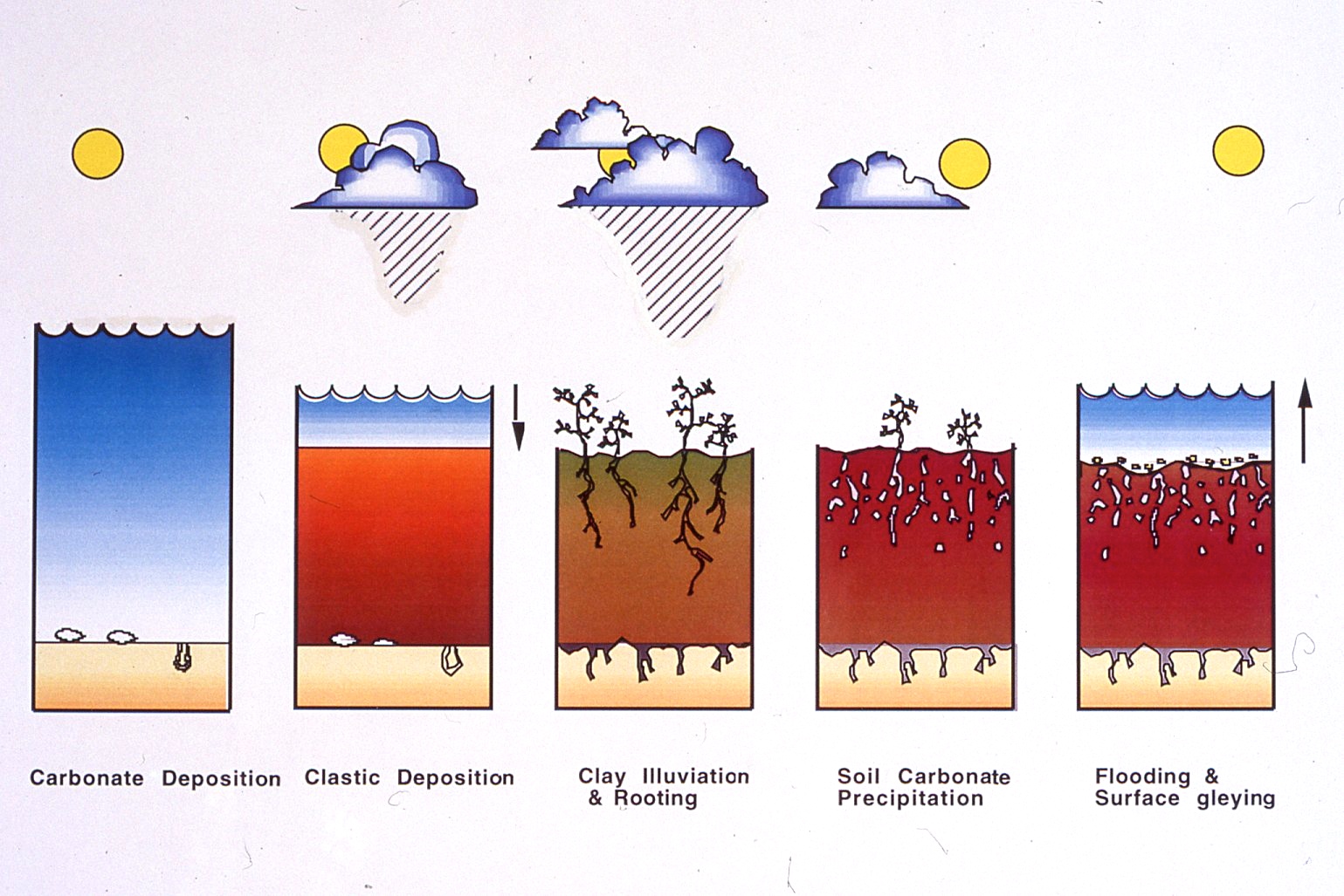
annual precipitation (Mack, 1992). A diagram illustrating the
proposed climatic changes associated with the formation of these
complex paleosol profiles is shown in Figure 8.

Figure 8. Diagram showing interaction of sealevel change and climate
change on the formation of paleosols as interpreted by the model
described herein. Arid to semi-arid conditions prevailed during
sealevel rise and highstand. Seasonally wet climates were associated
with falling sealevel and deposition of siliciclastic muds. Pedogenesis
followed first under humid conditions resulting in illuviated clays,
and subsequently under sub-humid to semi-arid conditions producing
carbonate nodules and rhizocretions.
Within some cyclothems, rooted
reddish-brown siltstones are
preserved at the tops of silty paleosol profiles. Some siltstone beds
are also distinct lithologic units. They weather spheroidally and bear
a striking resemblance to loessites described from the Ancestral
Rockies and elsewhere. The silts of the midcontinent may have been
derived from the extensive Permian eolian dunefields to the west. Wind
directions determined from both eolian dune crossbeds and paleoclimate
models indicate winds from the northwest during the Wolfcampian
(Johnson, 1989; Soreghan, 1992). If these silts were windblown, their
occurrence at the top of paleosol horizons is consistent with sediment
trapping by a vegetated surface. Relatively high rates of sediment
aggradation would also account for only the early stages of pedogenic
development being present in the upper silty horizons. Siltstones also
increase in abundance upsection coincident with other lithologic
indicators of increased aridity during the course of the Permian (West
et al, 1997).
Another paleosol type is commonly found
within cyclothems
of the Council Grove Group. These paleosols are characterized by
columnar-shaped ped structures with rounded tops, and typically occur
in underlying or overlying carbonate units with evaporitic features. In
modern soil-forming environments, these columnar peds occur only under
the influence of sodium domination, and are referred to as natric
horizons (Birkeland, 1984). The columnar peds in the Wolfcampian
paleosols of northcentral Kansas all display the typical morphology
found in extant natric horizon soils (McCahon & Miller, 1997).
Columnar peds are distinguishable from argillic prismatic peds, also
present in the paleosols, by the presence of domed rather than flat
surfaces at the top of the peds in the B horizons.
The paleosols occurring at the top of
the variegated mudstone intervals
are dominated by vertic features. These paleosol profiles lack clearly
developed horizonation and have a uniform greenish gray to yellowish
gray color. Their most prominent features are pseudoanticlines (mukkara
structure) with pedogenic slickensides. The hummocky surface relief
(gilgai) associated with these structures are especailly well-displayed
if horizontal exposures are available (see Miller et al., 1996). In
some profiles the curved fractures of the pseudoanticlines are enhanced
by carbonate precipitation along the fractures. The carbonate is
generally micritic with a botryoidal surface texture, although it may
also be sparry calcite. Carbonate nodules, isolated or less commonly
stacked, and small (<5mm) sesquioxide nodules are also present
in
the matrix. Root traces are abundant and sometimes take on a
"concertina" appearance. These paleosols can be classified as Vertisols
(Soil Survey Staff, 1992) or calcic Vertisols (Mack et al., 1993).
The pseudoanticlines and pedogenic
slickensides of the vertic paleosols were produced by the shrinking and
expansion of clay-rich soils in response to wetting and drying in a
markedly seasonal or monsoonal climate. The uniform green to
yellowish color of these profiles suggests saturation of the soil
during part of the year, and the lack of horizonation is consistent
with the extensive turbation characteristic of Vertisols. The
relatively high organic carbon contents (~1-2%) and presence of
disseminated charcoal also reflect high rates of soil turbation, and an
extended dry season. As for the calcic soils, the abundant
carbonate nodules found in the upper part of some vertic soil profiles,
such as in the Roca Shale, suggest a trend toward drier conditions
during later phases of soil development.
CLIMATIC-EUSTATIC
MODEL
As stated above, the early Permian was a
time of continental galciation in the southern Hemisphere continents of
Gondwana. Glacial advance and retreat would be associated
with both global cyclical sealevel fluctuation and climate
change. The consistent carbonate to siliciclastic pattern of
meter-scale cycles, within both the open marine facies and
paleosol-bearing intervals of cyclothems, indicates that
glacio-eustatic seaelvel change alone is not adequate to explain the
observed cyclicity. A model for climatic control over facies
development proposed by Cecil (1990) provides a basis for developing a
more complete model of cyclothem formation. In this model,
clastic sediment transport is predicted to be highest in seasonal
wet-dry climates and lower in both arid and tropical wet
climates (see also Wilson, 1973; Perlmutter &
Matthews, 1989). Carbonates and evaporites accumulate during
arid and semiarid conditions, and mappable coal beds form during
relatively wet climates when clastic influx is low. Because
carbonates typically overlie the flooding surfaces of meter-scale
cycles, acceptance of Cecil's model would indicate that drier
conditions were associated with sealevel rise (interglacials) and
wetter climates associated with sealevel fall (glacials).
Combining the climate model of Cecil
(1990) with the paleosol evidence gives the following scenario for
cycle formation. Arid to semi-arid conditions prevailed
during sealevel rise and highstand resulting in carbonate
precipitation. Falling sealevel was associated with a
transition to seasonally wet climates that initiated the influx of
siliciclastic muds. These siliciclastic muds were subaerially
exposed with continued sealevel fall. Pedogenesis followed
first under humid conditions resulting in clay illuviation, and
subsequently under semi-arid conditions producing carbonate nodules and
rhizocretions. Flooding of the land suface by rising sealevel
truncated the soils and formed the thin intraclastic and skeletal
lags. At the cyclothem-scale, a general trend toward wetter
conditions is recorded by the change from calcic to vertic
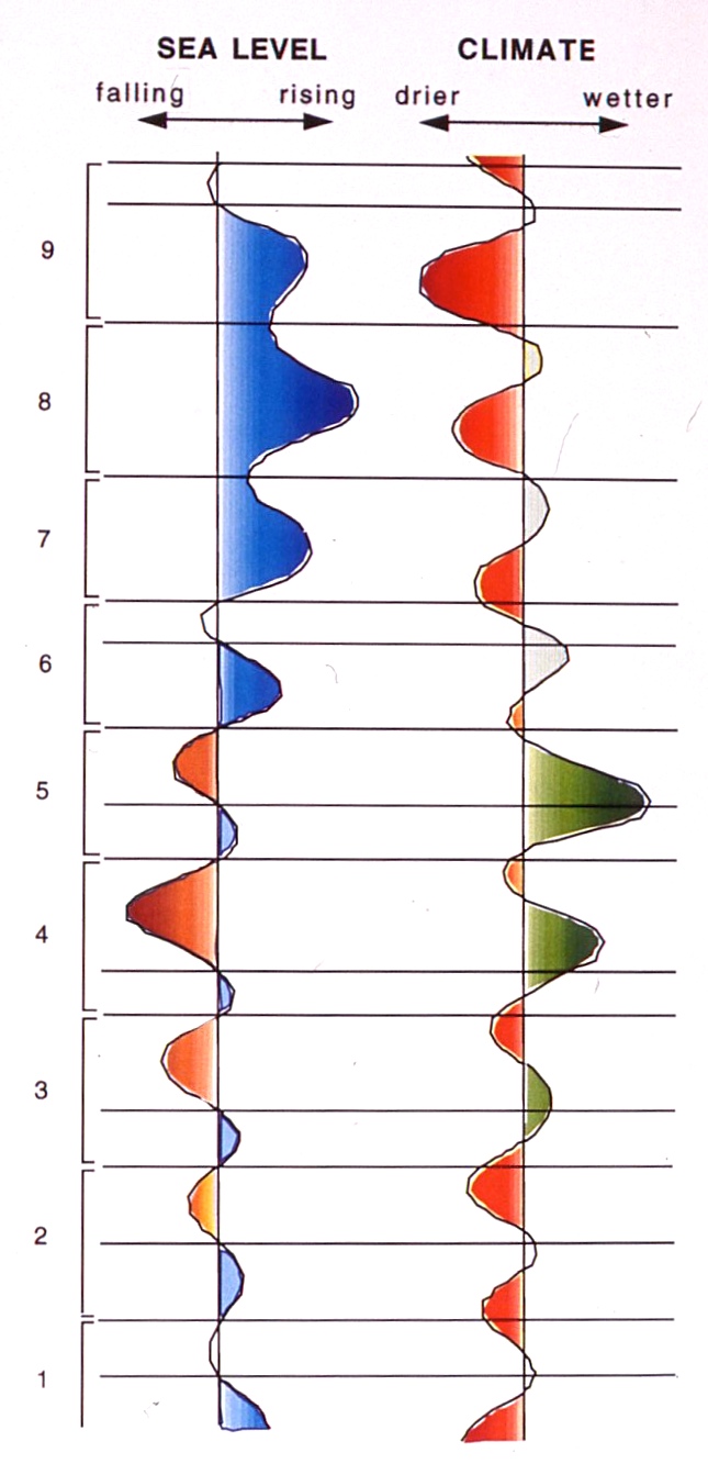
paleosols. The proposed relationship between cycles formation
and sealevel climate change is illustrated in Figure 9.


Figure 9. Stratigraphic section for Tuttle Creek spillway with
interpreted sealvel and climate surves. Note the short-term climatic
fluctuations superimposed on the cyclothem-scale pattern.
Because both eustacy and climate are
intimately connected to the dynamics of glacial advance and retreat,
some consistent relationship should be expected. A model incorporating
both climate change and glacio-eustatic sealevel fluctuation has been
proposed for the Wolfcampian of the mid-continent (Miller et al.,
1996). Global circulation models (Parrish & Peterson, 1988;
Kutzbach & Gallimore, 1989; Patzkowsky et al., 1991; Parrish,
1993) indicate a change from the dominance of zonal circulation in the
Late Pennsylvanian, to the increasing influence of monsoonal
circulation in the Permian, diverting the moisture-laden equatorial
easterlies flowing from the Tethys, and resulting in a drying of
equatorial Pangea. Furthermore, both climate models (Kutzbach &
Guetter, 1984) and paleoclimate data (Fairbridge, 1986; Crowley
& North, 1991) indicate that monsoons are strengthened during
interglacial periods and significantly weakened during glacial periods.
The proposed climatic/eustatic model
assumes that the climate of the mid-continent was strongly affected by
a Pangean monsoon, and that fluctuations in the intensity of the
monsoon produced oscillations between wetter and drier conditions.
During interglacial periods when the monsoon was strong, the wet
equatorial air would have been diverted to the north or south,
resulting in a dry midcontinent. However, the weakening of the monsoon
during glacial periods would have permitted the equatorial easterlies
to penetrate into the continental interior. This model predicts that
strong monsoons during sealevel highstands would have been associated
with more arid conditions resulting in the precipitation of pure
carbonates and evaporites, and weakened monsoons during sealevel
lowstands would have been associated with wetter conditions resulting
in argillaceous and silty carbonates and mudstones (Miller et al.,
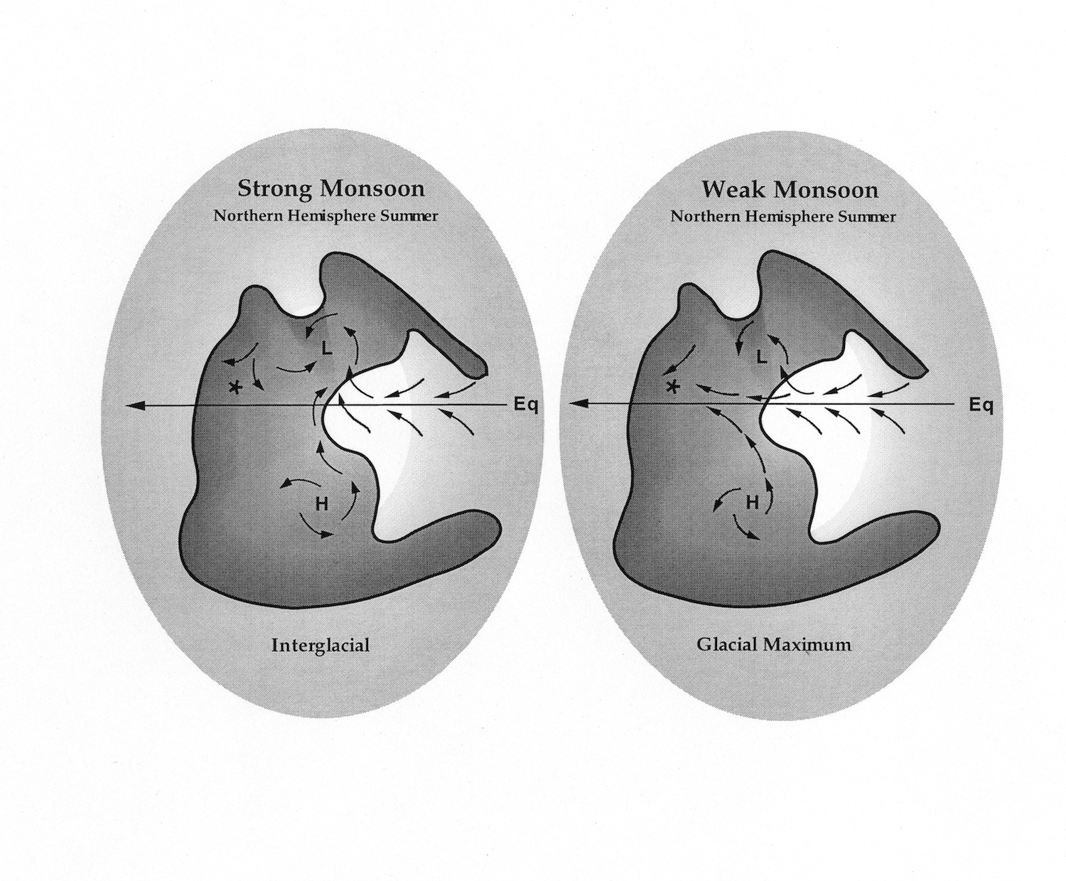
1996). Figure 10 shows the contrasting atmospheric circulation patterns
associated with glacial maximums and interglacials according to our
model.

Figure 10. Changes in equatorial circulation patterns across Pangea
between glacial and interglacial periods during the Lower Permian.
According to the model presented here, low pressure cells over the
supercontinent intensified during interglacials deflecting
moisture-laden equatorial easterlies. This monsoonal circulation
weakened during glacials allowing more moisture to reach the
continental interior.
Ice
volume changes during the Pleistocene have been attributed to
variations in solar insolation resulting from periodic changes in the
Earth's orbit and axial tilt. the five primary "Milankovitch
periodicities" are 413,000, 100,000, 41,000, 23,000, and 19,000 years
(Crowley & North, 1991). Time estimates for the duration of
Pennsylvanian and Permian cyclothems are not well constrained, varying
between 250,000 and 400,000 years. Although probably falling with the
range of 40,000 to 150,000 years (Heckel, 1986; Busch & West,
1987), the absolute time duration of meter-scale cycles is at present
impossible to obtain. Most time within a cycle is represented by
paleosols, exposure surfaces and flooding surfaces. Some individual
paleosol profiles could easily have developed over time periods of
several tens of thousands of years. Cycle periodicities thus will tend
to be overestimated by an order of magnitude or more by a simple
division of stage duration by number of cycles (Algeo &
Wilkinson, 1988). Thus, while estimated cycle periods fall within the
Milankovitch band, there is no way at present to identify specific
Milankovitch orbital periodicities.
CONTINUE
KANSAS FLINT HILLS GEOLOGY
NEXT


